Updated · View the original (2020)
Aerial Photography for Real Estate: 10 Ways Drones Sell Texas Homes
Some homes cannot be understood from the ground. A five-acre spread outside Fredericksburg, a lakefront lot on Lake Travis, a new build backing to a greenbelt: the thing that makes them worth the price is the land and the setting, and the land and the setting are exactly what a chest-height camera cannot show. This is the problem aerial photography exists to solve. Lift the camera a hundred feet and the property finally reads the way it does in person, as a home in a place, with a boundary, a view, and a relationship to everything around it.
Drone imagery has moved from novelty to baseline in the years since it became legal for commercial work. The National Association of REALTORS reports that 52% of agents now use drone photography or video, and on larger or higher-priced Texas listings the share is effectively total. What follows are ten reasons aerial belongs on your shoot, deepened for the way homes actually sell today, plus the one piece of the process that legally has to be handled by a licensed operator.
1. It shows the whole property at once
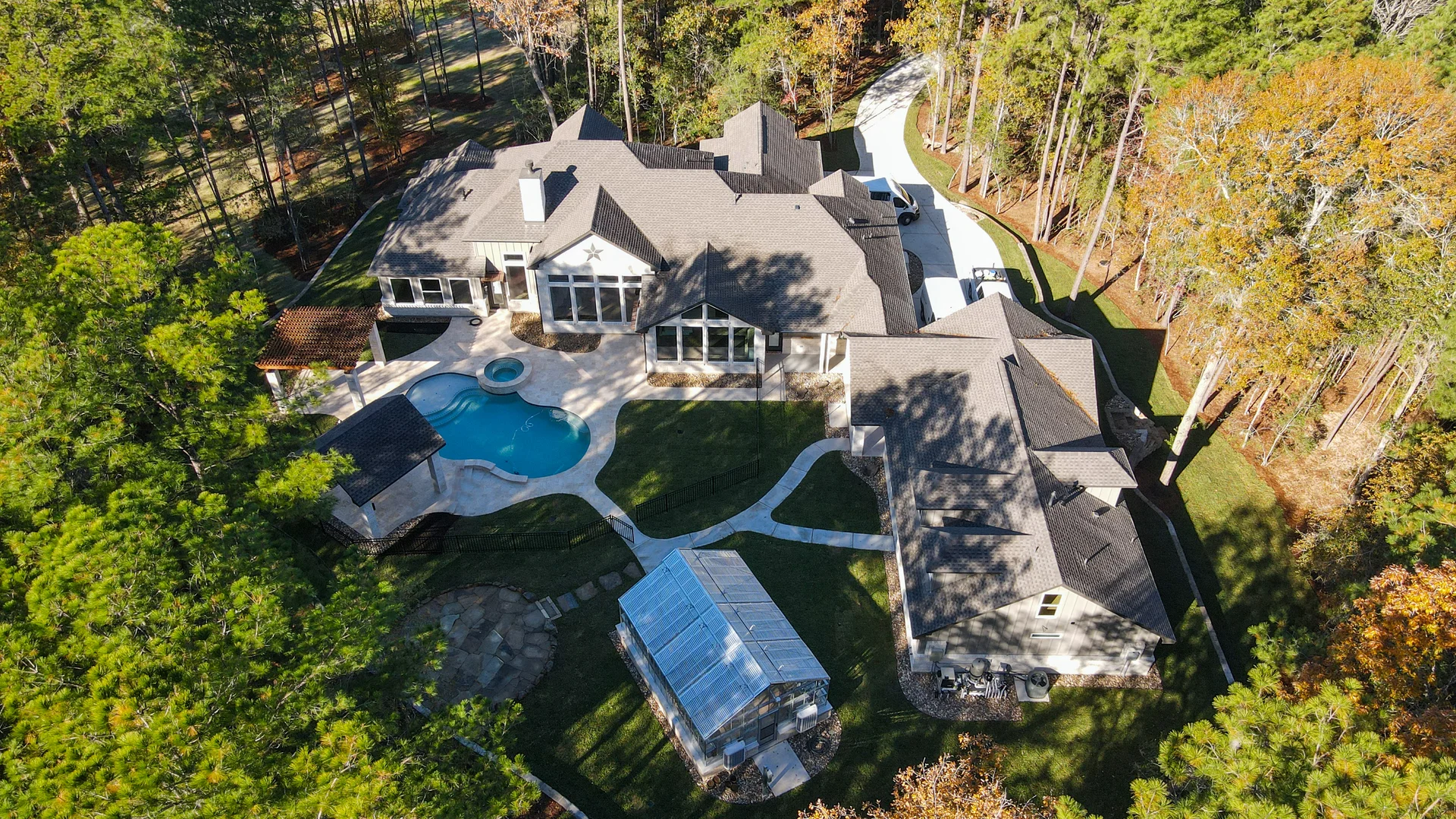
The single thing aerial does that nothing else can is present a home and its land in one honest frame. From the ground you shoot a house one wall at a time and leave the buyer to assemble the pieces. From the air you show the footprint, the roof, the driveway, the pool, the outbuildings, the treeline, and where the lot actually ends, all in a single image the eye takes in at a glance.
For acreage that is not a nice-to-have, it is the listing. A buyer shopping for room to breathe wants to see the fence lines, the pasture, the pond, and how the house sits on the parcel. A grade-level photo of a big lot just looks like a yard. An aerial makes the scale legible, which is the whole reason someone is paying for the acres.
2. It puts the home in its setting
Location sells, and aerial is the only way to actually show location rather than assert it in the listing remarks. From above you can frame the Hill Country ridgeline behind the house, the golf course two doors down, the lake at the end of the street, or the greenbelt the back fence opens onto. You can show that a home is walkable to a park, backs to open land instead of another rooftop, or sits on a quiet cul-de-sac rather than a through street.
Those are the facts a relocating buyer cannot verify from six hundred miles away, and Texas takes in a steady stream of out-of-state buyers who shop online long before they visit. A well-composed aerial answers the questions text cannot: what is next door, what is the view, and what does this neighborhood actually feel like. That context is worth as much as any interior shot on a property where the setting is the selling point. Our Hill Country corridor and Austin listings lean on it constantly.
3. It reads as professional, not as a gimmick
When drone work was new it signaled that an agent was cutting-edge. That era is over, and the signal has inverted: with a majority of agents now using aerial, its absence is what gets noticed. A luxury or acreage listing with no aerial reads as under-marketed, and sellers comparing listing presentations notice which agent showed up with the full toolkit and which one did not.
Aerial is also part of how a listing looks like it was handled with care. It sits alongside professional stills, video, and a clean floor plan as evidence that the property is being represented seriously. Buyers read that signal too, consciously or not: a home presented completely feels like a home that has been well kept.
4. It gives a truer sense of scale and layout
Ground-level photography distorts. A wide lens in a corner can make a room feel bigger than it is, and a low angle on a facade can make a house loom in a way that reads as intimidating rather than grand. An elevated exterior corrects that. From a modest height, roughly rooftop level, the proportions of the house settle into something honest, and the buyer sees the real relationship between the home, the yard, and the street.
Aerial also answers layout questions that interiors leave open. How the primary suite wing relates to the garage, where the pool sits relative to the covered patio, how the guest casita or workshop is positioned on the lot: these are spatial relationships a walkthrough gallery never quite resolves, and one clear overhead frame makes them obvious. Paired with a 3D tour or floor plan, aerial completes the buyer's mental model of the property before they ever pull into the driveway.
5. It reaches shots the ground makes impossible
Waterfront is the classic case. The best angle on a lake house is from out over the water, looking back at the facade and the shoreline, and there is no way to stand there. A drone simply flies to the spot. The same is true for a home whose best face is blocked by mature trees, a steep grade, a long gated drive, or a neighbor's structure crowding the property line. Elevation clears the obstruction and finds the composition that was always there but unreachable on foot.
This is where aerial earns its keep on the hardest-to-shoot properties in the state: bluff lots, ranch entrances, homes set deep on wooded acreage, anything where the ground-level vantage points all fight you. The camera goes where a photographer cannot, and the property finally gets the frame it deserves.
6. It captures motion, not just stills
A drone is a video platform as much as a camera. A slow rise over the roofline to reveal the land behind, a smooth push toward the front door, an orbit that walks the eye around the whole property: aerial motion gives a listing a cinematic opening that a still cannot. This matters because buyers now expect to move through a home before they visit. Google and NAR found that 70% of home shoppers use video to tour a home, and an aerial reveal is often the most-watched few seconds of a listing tour.
The strongest listing videos usually open in the air and land on the ground, tying the property's setting to its interior in one continuous piece. That establishing move, from neighborhood to lot to front door, is something only an aerial camera can start. See how we build it into listing video.
7. It is backed by how homes actually sell
The case for aerial does not rest on hype, it rests on the same evidence that supports professional media generally. Redfin found that homes between $200,000 and $1 million shot with a professional camera sold for $3,400 to $11,200 more relative to list than homes with amateur photos, and immersive media compounds that: Matterport reports listings with a 3D tour sold up to 31% faster and for up to 9% more. Aerial is part of that complete-media package, and on land-driven properties it is the part that carries the most weight.
The adoption numbers tell the same story from the other side. When 52% of agents already fly, aerial is no longer an advantage you gain by adding it, it is a disadvantage you take on by skipping it. On acreage and luxury especially, it has quietly become table stakes.
8. It sets your listing apart in a crowded market
Even as adoption climbs, plenty of listings still go up with a single blurry ground shot and nothing above eye level. On the search grid, where buyers decide in a fraction of a second whether to click, an aerial hero image stops the scroll in a way another shot of a garage door never will. A twilight aerial of a home glowing against the last light over the Hill Country is about as strong a thumbnail as real estate offers, and it pairs naturally with twilight photography on the ground.
For the agent, that difference is also a listing-presentation tool. Sellers choose the agent who shows them the sharpest plan for marketing their specific property, and for a home where the land, the view, or the setting is the story, walking in with an aerial strategy is often what wins the listing.
9. It has to be flown by an FAA-licensed operator
This is the benefit that is really a requirement, and it is the reason aerial is best handled by a professional rather than a phone-and-drone hobbyist. Any drone flight for a real estate listing is commercial work, and commercial drone operation in the United States is governed by FAA Part 107. The pilot must hold a Remote Pilot Certificate, which requires passing an aeronautical knowledge test and a TSA background check, and must keep it current with recurrent training. The aircraft must be registered and broadcast Remote ID, and flights are bound by real rules: a 400-foot altitude ceiling, daylight or civil-twilight operation with anti-collision lighting after dark, and airspace authorization near airports, which matters across the dense airspace around Houston, Dallas, and Austin.
A licensed operator handles all of that as a matter of course, along with the insurance and the judgment to fly safely over an occupied property. Hiring the flight out is not a shortcut, it is compliance. It means the imagery on your listing was captured legally, which protects you as much as it protects the pilot. It is a core reason our aerial photography is done by certificated pilots, not contractors of convenience.
10. It tells the story of the land
Beyond every practical argument, aerial does something emotional that no interior shot can. It lets a buyer hover above a place and feel what it would be to own it: the sweep of the acreage, the way the drive winds up to the house, the pond catching the light, the land rolling out to the horizon. That sensation of surveying your own ground is exactly the feeling that sells rural and luxury property, and it is the feeling aerial delivers better than any other tool.
On a property with real land, that story is the point. A buyer cannot fall in love with acreage they cannot comprehend, and they cannot comprehend it from a photo of the front porch. The aerial gives them the scope to see the whole of what they are buying, and the emotional pull to want it. That is why, on the right property, it is not the finishing touch. It is the lead.
Aerial as part of a complete listing
Drone imagery is at its strongest when it is not an afterthought but one layer of a coordinated shoot: aerial to place the home in its setting, professional stills to sell the interiors, video to give it motion, and a 3D tour or floor plan to make the layout clear. Captured together in a single visit, those pieces share a consistent look and tell one continuous story, from the ridgeline down to the front door.
If your next listing is defined by its land, its view, or its setting, that is precisely the property that under-sells from the ground and comes alive from the air. See how we cover it across every Texas market we serve.